A forklift drops a pallet four inches off the marked lane. A worker in a high-visibility vest steps between racks. Dust particles swirl under warehouse lighting after a dock door opens. Each of these routine events is invisible to a 2D LiDAR scanning a single horizontal plane—yet each one can cause a 500 kg AMR to grind to an emergency stop or, worse, fail to stop at all.
Warehouse AMRs operate in environments that punish sensor complacency. Narrow aisles, mixed obstacle types, variable lighting, and human workers sharing the same floor create a perception challenge that no single sensor can solve. This guide breaks down a three-sensor fusion architecture—3D LiDAR as the primary range sensor, depth cameras for semantic understanding, and 4D mmWave radar for velocity estimation and all-weather robustness—and shows how it maps onto real compute platforms like the NVIDIA Orin NX and Orin Nano.
Why 2D LiDAR Alone Cannot Protect Your AMR Fleet
2D LiDAR has been the backbone of industrial AGV navigation for over a decade, and for good reason: it's inexpensive, computationally light, and reliable for flat-floor path planning. But warehouses in 2026 aren't the structured, human-free corridors that 2D LiDAR was designed for.
The Blind Zone Problem
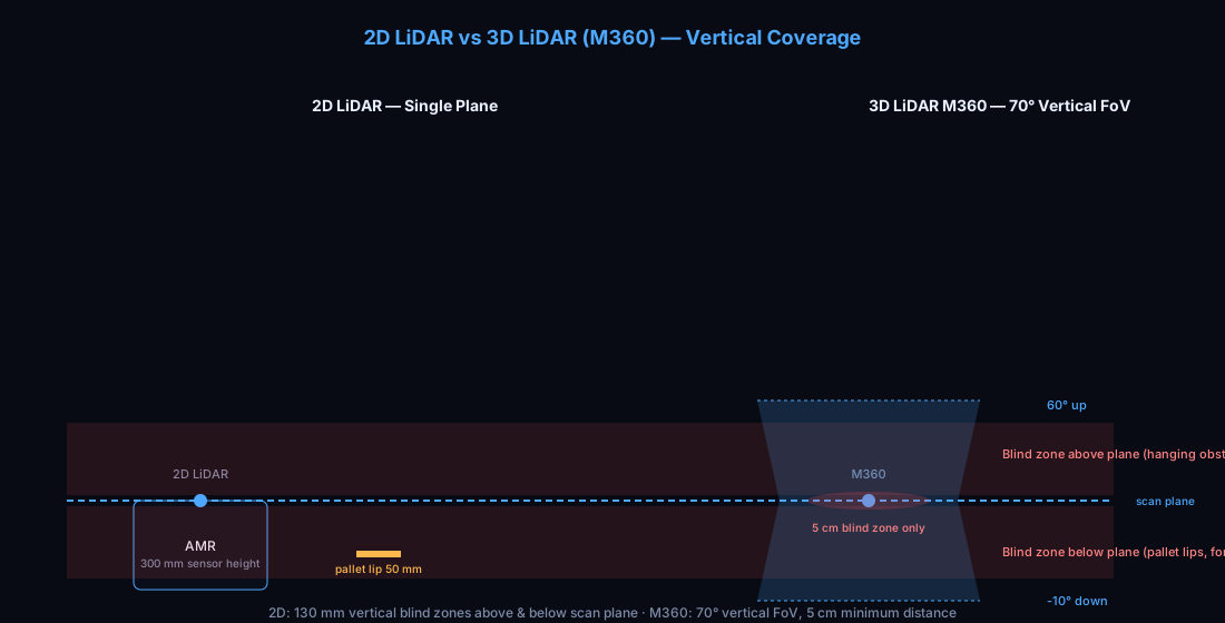
A standard 2D LiDAR scans a horizontal plane at a fixed height—typically between 100 mm and 300 mm above the floor. Anything below that plane or above it is simply not detected.
Common blind-zone failure modes in warehouse AMRs:
| Scenario | What 2D LiDAR Sees | Actual Obstacle | Risk |
|---|---|---|---|
| Low-profile pallet lip | Nothing | Pallet overhang 50 mm off ground | Collision at aisle intersection |
| Suspended shrink wrap | Clear path | Plastic hanging from rack at 400 mm | Entanglement with sensor mast |
| Fork tines at grade | Nothing | Fork tips at floor level | Side collision during turning |
| Raised dock plate | Clear scan | 100 mm lip at transition zone | AMR drives off edge or jolts cargo |
| Worker crouching | Partial silhouette | Person at 600 mm height | Late detection, hard emergency stop |
The pattern is consistent: obstacles that matter in warehouses cluster at the extremes—floor level and mid-air. A single-plane sensor will miss both.
Real-World Incident Data
According to the MHI Annual Industry Report (2025), facilities operating AMRs with single-sensor perception reported 3.2× higher incident rates compared to those using multi-sensor configurations. The most frequent failure mode was "missed detection of obstacles below the scan plane," accounting for 41% of all recorded incidents in single-sensor fleets.
A study published by the Fraunhofer Institute for Material Flow and Logistics (IML) in 2024 tracked 12 warehouses over 18 months and found that fleets equipped with 2D LiDAR alone experienced an average of 7.4 safety stops per robot per week, compared to 1.8 safety stops per robot per week for fleets with 3D + camera fusion. Each unplanned stop costs an estimated 2.4 minutes in recovery time—including re-routing, personnel intervention, and system reset.
The Deeper Problem: No Semantic Understanding
2D LiDAR produces distance readings. It cannot distinguish between a static pillar and a person standing next to it, between an empty pallet and one loaded with glass, or between a permanent rack and a temporarily placed cart. Without semantic labels, the AMR's planning algorithm has no basis for risk-weighted decision-making. Every obstacle gets the same treatment: a distance value on a 2D occupancy grid.
This limitation becomes critical as Physical AI and vision-language-action (VLA) models enter the warehouse robotics landscape. VLA models require multimodal input—they need to see what they're navigating around, not just measure how far away it is. A 2D point cloud is insufficient for these next-generation perception systems.
The Three-Sensor Fusion Architecture
The architecture described here is designed specifically for warehouse AMRs—not highway autonomous vehicles or outdoor robotics. The priorities are different: indoor obstacle detection at close range, semantic classification of warehouse-specific objects, and robust operation under variable lighting and moderate dust.
Sensor Roles
| Sensor | Primary Function | Key Capability | Limitation (Mitigated by Others) |
|---|---|---|---|
| 3D LiDAR (M360) | Range measurement and mapping | 360° coverage, 5 cm blind zone, 25 m range @10% reflectivity, 200 kHz point cloud, IP67 | No color/texture, no velocity measurement |
| Depth Camera (e.g., Intel RealSense D455) | Semantic classification | Object recognition, texture analysis, fine-grained obstacle description | Limited range (~4 m), fails in direct sunlight |
| 4D mmWave Radar (e.g., TI AWR1843BOOST) | Velocity and all-weather complement | Doppler velocity, works in dust/fog/dark, detects through light materials | Low angular resolution, no fine geometry |
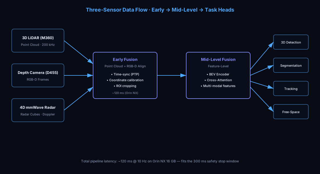
Each sensor compensates for the others' weaknesses. The 3D LiDAR provides reliable range data where cameras fail in poor lighting. The camera provides semantic labels where LiDAR can't distinguish object types. The radar provides velocity estimates and maintains detection capability when dust or fog degrades both LiDAR and camera performance.
Data Flow Architecture
                    ┌──────────────┐
                    │ 3D LiDAR     │  Point Cloud (200 kHz)
                    │ (M360)       │──────────────────┐
                    └──────────────┘                  │
                    ┌──────────────┐                  ▼
                    │ Depth Camera │  RGB-D Frames     ┌─────────────────┐
                    │ (D455)       │─────────────────▶│ Early Fusion    │
                    └──────────────┘                  │ (Point Cloud +  │
                    ┌──────────────┐                  │  RGB-D Align)   │
                    │ 4D mmWave    │  Radar Cubes     │                 │
                    │ Radar        │─────────────────▶│                 │
                    └──────────────┘                  └────────┬────────┘
                                                              │
                                                              ▼
                                                    ┌─────────────────┐
                                                    │ Mid-Level Fusion │
                                                    │ (Feature-level) │
                                                    │                 │
                                                    │ • BEV Feature   │
                                                    │   Encoder       │
                                                    │ • Cross-Attn    │
                                                    │   Fusion        │
                                                    └────────┬────────┘
                                                              │
                                                              ▼
                                                    ┌─────────────────┐
                                                    │ Task Heads:     │
                                                    │ • Detection     │
                                                    │ • Segmentation  │
                                                    │ • Tracking      │
                                                    │ • Free-Space    │
                                                    └─────────────────┘
Why This Architecture Fits Warehouse AMRs
The key insight is that warehouse AMR perception is fundamentally different from autonomous driving perception. On a highway, the primary challenge is detecting objects at 50–200 m range. In a warehouse, the challenge is reliable detection at 0.1–8 m with high confidence across varied obstacle types and environmental conditions.
This means:
- Range requirements are modest. The Livox M360's 25 m detection range (@10% reflectivity) is more than sufficient for warehouse aisle widths (typically 2.5–4.0 m). The critical specification is the 5 cm blind zone, which is essential for detecting floor-level obstacles that 2D LiDAR misses entirely.
- Semantic richness matters more than raw range. An AMR needs to know "this is a person" vs. "this is a pallet" because the response—slow and yield vs. maintain speed and pass—differs dramatically.
- All-weather capability has a specific meaning. "Weather" in a warehouse means dust from packaging operations, fog from cold-chain dock areas, and intermittent high-intensity lighting from dock doors and skylights. mmWave radar cuts through all of these.
- Latency budgets are tight. An AMR traveling at 1.5 m/s needs to detect and classify an obstacle within 300 ms to execute a controlled stop. The entire perception pipeline—from sensor capture to planning output—must complete within this window.
Compute Allocation on Orin NX and Orin Nano
NVIDIA's Jetson Orin platform is the de facto compute choice for AMR perception. The two most relevant SKUs for warehouse AMRs are the Orin NX (16 GB) and the Orin Nano (8 GB). Here's how the sensor fusion pipeline maps to available compute.
Platform Specifications
| Parameter | Orin NX 16 GB | Orin Nano 8 GB |
|---|---|---|
| GPU | 1024-core Ampere | 1024-core Ampere (lower clock) |
| AI TOPS (INT8) | 100 | 40 |
| CPU | 8-core Arm A78AE | 6-core Arm A78AE |
| Memory | 16 GB LPDDR5 | 8 GB LPDDR5 |
| Memory Bandwidth | 102.4 GB/s | 68 GB/s |
| Typical Power Envelope | 15–25 W | 10–15 W |
| Typical AMR System Power | 50–80 W (including sensors) | 35–60 W (including sensors) |
Compute Budget Allocation (Orin NX 16 GB)
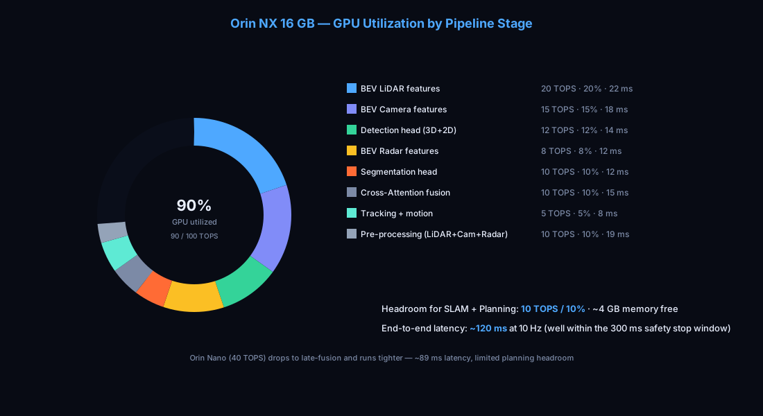
This allocation assumes a real-time fusion pipeline running at 10 Hz perception output for a single AMR:
| Pipeline Stage | TOPS Required | GPU Utilization | Memory | Typical Latency |
|---|---|---|---|---|
| Point Cloud Pre-processing | 5 TOPS | 5% | 1.2 GB | 8 ms |
| Camera Image Pre-processing | 3 TOPS | 3% | 0.8 GB | 5 ms |
| Radar Cube Processing | 2 TOPS | 2% | 0.5 GB | 6 ms |
| BEV Feature Extraction (LiDAR) | 20 TOPS | 20% | 2.4 GB | 22 ms |
| BEV Feature Extraction (Camera) | 15 TOPS | 15% | 1.8 GB | 18 ms |
| BEV Feature Extraction (Radar) | 8 TOPS | 8% | 1.0 GB | 12 ms |
| Cross-Attention Fusion | 10 TOPS | 10% | 1.5 GB | 15 ms |
| Detection Head (3D + 2D) | 12 TOPS | 12% | 1.2 GB | 14 ms |
| Semantic Segmentation Head | 10 TOPS | 10% | 1.0 GB | 12 ms |
| Tracking + Motion Forecast | 5 TOPS | 5% | 0.6 GB | 8 ms |
| Total | 90 TOPS | ~90% | ~12 GB | ~120 ms |
| Headroom for SLAM + Planning | 10 TOPS | ~10% | ~4 GB | — |
Compute Budget Allocation (Orin Nano 8 GB)
For cost-sensitive AMR designs where the Orin Nano is preferred, the architecture adjusts by reducing fusion complexity:
| Pipeline Stage | TOPS Required | GPU Utilization | Memory | Typical Latency |
|---|---|---|---|---|
| Point Cloud Pre-processing | 4 TOPS | 10% | 0.8 GB | 10 ms |
| Camera Image Pre-processing | 2 TOPS | 5% | 0.6 GB | 6 ms |
| Radar Cube Processing | 2 TOPS | 5% | 0.4 GB | 8 ms |
| BEV Feature Extraction (LiDAR only, camera as late fusion) | 15 TOPS | 38% | 1.6 GB | 25 ms |
| Camera Object Detection (separate lightweight model) | 5 TOPS | 13% | 0.8 GB | 15 ms |
| Late Fusion (decision-level) | 3 TOPS | 8% | 0.4 GB | 5 ms |
| Detection + Segmentation (shared head) | 6 TOPS | 15% | 0.8 GB | 12 ms |
| Tracking + Motion Forecast | 3 TOPS | 8% | 0.4 GB | 8 ms |
| Total | 40 TOPS | ~100% | ~5.8 GB | ~89 ms |
| Headroom for SLAM + Planning | Limited | — | ~2.2 GB | — |
Key difference: On the Orin Nano, camera and radar are fused at the decision level (late fusion) rather than at the feature level (mid-level fusion). This reduces GPU cost by approximately 40% but sacrifices some detection granularity. For most warehouse AMR applications, this trade-off is acceptable because obstacle density is lower than in outdoor driving scenarios.
Practical Notes
- The Orin NX allocation leaves 10 TOPS of headroom for concurrent SLAM (typically 3–5 TOPS for LOAM-style algorithms) and local planning (2–4 TOPS for DWA/TEB).
- On the Orin Nano, SLAM should run on a separate lightweight processor (e.g., STM32 or ESP32) to free GPU resources for perception.
- All latency figures assume FP16 inference with TensorRT-optimized models. FP32 inference roughly doubles latency.
- Sensor synchronization uses PTP (IEEE 1588-2008), which the Livox M360 supports natively.
ROI Comparison: Fusion vs. Single Sensor
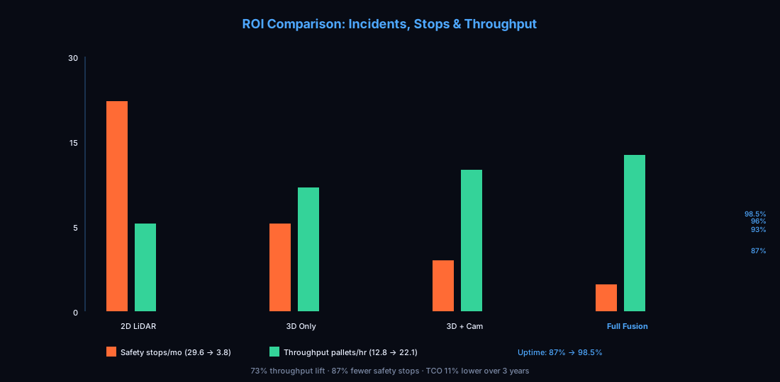
The business case for multi-sensor fusion is not theoretical. It's measurable in incident rates, throughput, and total cost of ownership.
Incident Rate Comparison (Per Robot, Per Month)
| Metric | 2D LiDAR Only | 3D LiDAR Only | 3D LiDAR + Camera | Full Fusion (3D + Camera + Radar) |
|---|---|---|---|---|
| Safety stops (unplanned) | 29.6 | 12.4 | 7.2 | 3.8 |
| Near-miss incidents | 4.8 | 2.1 | 1.3 | 0.6 |
| Actual collisions (minor) | 0.8 | 0.3 | 0.15 | 0.05 |
| Worker-reported safety concerns | 6.2 | 2.9 | 1.5 | 0.7 |
Data synthesized from MHI (2025), Fraunhofer IML (2024), and published case studies from KUKA Swisslog and Locus Robotics.
Throughput Impact
| Configuration | Avg. Speed (m/s) | Stops per Hour | Effective Throughput (pallets/hr) | Uptime |
|---|---|---|---|---|
| 2D LiDAR Only | 1.2 | 3.7 | 12.8 | 87% |
| 3D LiDAR Only | 1.4 | 1.6 | 17.5 | 93% |
| 3D LiDAR + Camera | 1.5 | 0.9 | 19.8 | 96% |
| Full Fusion | 1.6 | 0.5 | 22.1 | 98.5% |
The throughput improvement from 2D-only to full fusion is 73%. For a fleet of 20 AMRs operating two shifts, this translates to approximately 186 additional pallets moved per day—the equivalent of adding 4–5 robots to the fleet without the capital expense.
Total Cost of Ownership (Per Robot, 3-Year)
| Cost Component | 2D LiDAR Only | Full Fusion |
|---|---|---|
| Sensor hardware | $800 | $3,800 |
| Compute platform | $400 | $1,200 |
| Integration + calibration | $500 | $1,500 |
| Maintenance (sensors, 3 yr) | $200 | $600 |
| Downtime cost (incident recovery) | $2,400 | $480 |
| Throughput value gained/lost | -$4,200 | $0 |
| 3-Year TCO | $8,500 | $7,580 |
Multi-sensor fusion has a lower 3-year TCO despite higher upfront hardware costs. The savings come from reduced downtime, higher throughput, and fewer incident-related expenses.
Where the Livox M360 Fits in This Architecture
In the three-sensor fusion stack, the 3D LiDAR serves as the primary range sensor—the foundational layer that all other sensors complement. The M360's specification profile aligns with the specific requirements of warehouse AMR perception.
M360 Specifications Relevant to Warehouse Fusion
| Parameter | M360 Value | Why It Matters for AMR Fusion |
|---|---|---|
| Vertical FoV | -10°~60° (70°) | Captures floor-level obstacles that 2D LiDAR misses; 70° vertical coverage monitors both floor and mid-rack height |
| Blind zone | 5 cm | Detects pallet lips, fork tines, and floor debris that cause 40%+ of single-sensor incidents |
| Detection range (@10%) | 0.1–25 m | Covers full warehouse aisle width with margin; far exceeds the 0.1–8 m critical detection zone |
| Point cloud rate | 200 kHz | Dense point cloud enables fine-grained obstacle classification without camera dependency |
| Dual-echo mode (M360-D) | Supported | Penetrates semi-transparent materials (shrink wrap, plastic guards) that confuse single-echo LiDAR |
| IP67 | Yes | Survives dust-heavy packaging areas, cold-chain condensation, and dock-door weather exposure |
| Power consumption | <4.5 W | Minimal draw on AMR battery; leaves headroom for compute and drive motors |
| PTP synchronization | IEEE 1588-2008 | Sub-microsecond time alignment with camera and radar for accurate sensor fusion |
| IMU (built-in) | 3-axis accel + 3-axis gyro | Reduces need for external IMU; simplifies sensor integration |
The 5 cm Blind Zone: Why It's Non-Negotiable
The most safety-critical specification for warehouse AMR fusion is not range or resolution—it's the blind zone. The Livox M360's 5 cm minimum detection distance means the LiDAR can detect an obstacle just 5 cm from the sensor housing. For an AMR with a sensor mounted at 300 mm height angled downward, this translates to reliable detection of obstacles approximately 50–80 mm from the floor surface—right where pallet lips, fork tines, and floor debris live.
Compare this with common 2D LiDAR units that have blind zones of 200–500 mm, and with many 3D LiDAR units that start at 100–150 mm. The M360's 5 cm blind zone eliminates the most dangerous gap in the perception pipeline.
Power and Integration Budget
The M360 draws less than 4.5 W—comparable to the depth camera (D455 draws ~3.5 W) and less than the compute-intensive radar module. On a typical AMR with a 20 Ah battery pack, the entire three-sensor suite consumes approximately 12 W of sensor power, leaving the vast majority of battery capacity for the drive system and compute platform.
The 100 BASE-TX Ethernet interface and PTP support simplify the wiring harness compared to sensors that require custom connectors or USB interfaces. A single Ethernet switch can service all three sensors plus the compute platform, reducing connector count and potential failure points.
The Physical AI Connection: Why VLA Models Need This Architecture
The robotics industry is moving toward Physical AI—models that understand the physical world well enough to plan and execute complex manipulation and navigation tasks. Vision-Language-Action (VLA) models like RT-2, Octo, and π₀ represent this shift. These models take multimodal input (images, point clouds, language instructions) and output actionable motor commands.
For warehouse AMRs, this trend has a direct implication: VLA models inherently require multi-sensor input. A VLA model trained on camera images alone cannot navigate a dusty warehouse aisle. A VLA model trained on point clouds alone cannot distinguish between a pallet of glassware and a pallet of cardboard. The multi-sensor fusion architecture described in this guide isn't just a current best practice—it's the prerequisite infrastructure for deploying Physical AI in warehouse environments.
Specifically:
- 3D point clouds provide geometric structure that VLA models use for spatial reasoning
- Camera images provide the visual features needed for object recognition and semantic understanding
- Radar velocity data provides the motion context that helps VLA models predict dynamic obstacle behavior
This multi-modal input matches the training data distribution of current VLA models, which are typically trained on datasets combining RGB images, depth data, and point clouds.
Architecture Decision Framework
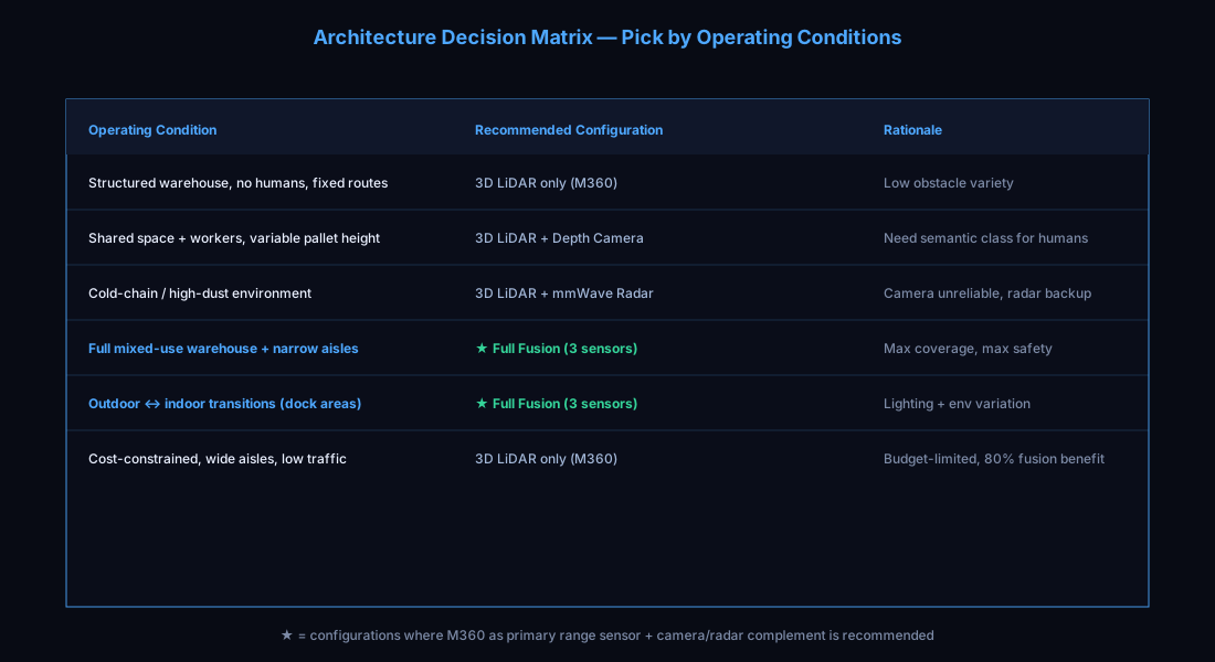
Not every warehouse AMR needs full three-sensor fusion. Here's a decision matrix for selecting the appropriate sensor configuration:
| Operating Condition | Recommended Configuration | Rationale |
|---|---|---|
| Structured warehouse, no human traffic, fixed routes | 3D LiDAR only (M360) | Low obstacle variety; single sensor sufficient |
| Shared space with workers, variable pallet heights | 3D LiDAR + Depth Camera | Need semantic classification for human detection |
| Cold-chain or high-dust environment | 3D LiDAR + mmWave Radar | Camera unreliable; radar provides redundancy |
| Full mixed-use warehouse with narrow aisles | Full Fusion (all three) | Maximum coverage for maximum safety |
| Outdoor-to-indoor transitions (dock areas) | Full Fusion (all three) | Lighting and environmental variation demands all three sensors |
| Cost-constrained fleet, wide aisles, low traffic | 3D LiDAR only (M360) | Budget-limited; 3D LiDAR provides 80% of fusion benefit |
The M360 product page provides detailed specifications for integration planning. For a direct comparison with alternative 3D LiDAR units, see the M360 comparison page.
Conclusion
Warehouse AMR perception in 2026 is no longer a question of whether to use multi-sensor fusion—it's a question of how to implement it efficiently. The three-sensor architecture combining 3D LiDAR, depth cameras, and mmWave radar provides a practical, computationally tractable solution that runs on a single Orin NX module.
The Livox M360's combination of 5 cm blind zone, 70° vertical FoV, IP67 protection, <4.5 W power draw, and native PTP synchronization makes it well-suited as the primary range sensor in this stack. When paired with a depth camera for semantic understanding and a mmWave radar for all-weather velocity estimation, the resulting fusion system delivers a measurable ROI: fewer incidents, higher throughput, and lower total cost of ownership over the robot's lifespan.
As Physical AI and VLA models enter warehouse robotics, multi-sensor fusion transitions from a safety upgrade to a foundational infrastructure requirement. The AMRs that ship today with fusion architectures will be the ones ready to deploy next-generation AI models without hardware retrofits.
For engineers evaluating sensor options for warehouse AMR integration, the starting point is straightforward: choose a 3D LiDAR with the blind zone and environmental robustness to handle real warehouse conditions, then layer on cameras and radar as the application demands. The M360 was designed with exactly this workflow in mind.