Flooding is the most common natural disaster worldwide, and accurate underwater terrain data is the foundation of every flood model. Without knowing the shape of a riverbed, the depth of a reservoir, or the profile of a coastal shelf, hydrologists can't predict where water will go, how deep it will get, or which communities are at risk. Traditional bathymetric surveys — multibeam sonar from a boat, lead-line sounding, or single-beam echo sounders — work, but they're slow, boat-access-dependent, and limited to navigable water.
Bathymetric LiDAR changes that. A 532nm green laser fired from an aircraft penetrates water and reflects off the seafloor, returning depth measurements from the air. It can survey shallow coastal zones, river channels, and lake beds from above, reaching areas that boats can't access. Agencies like NOAA, the U.S. Army Corps of Engineers, and the U.S. Geological Survey have been using it for decades. But recent sensor improvements and processing advances are expanding its role in flood monitoring specifically.
This article explains how bathymetric LiDAR works, where it fits relative to other survey methods, and why flood management agencies are integrating it into their workflows.
How Bathymetric LiDAR Works
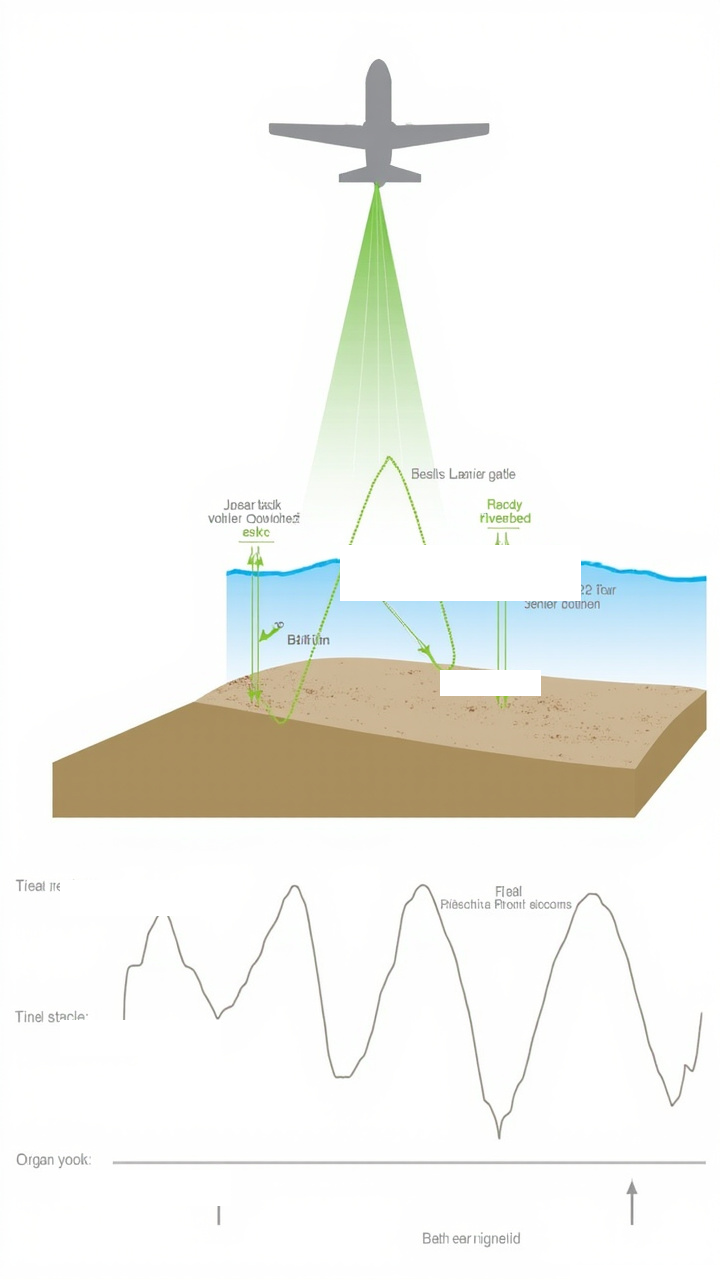
Standard topographic LiDAR uses near-infrared lasers (typically 1064nm) that reflect off solid surfaces but are absorbed by water — which is why conventional airborne LiDAR maps everything except what's underwater. Bathymetric LiDAR adds a second laser at 532nm, in the green portion of the visible spectrum, which penetrates water.
The physics: water absorbs red and infrared light quickly but transmits green and blue light more effectively. A 532nm green laser enters the water surface, travels downward, and reflects off the bottom (substrate). The time difference between the surface return and the bottom return gives the water depth. This is the same principle as a fish finder, but from 300-600 meters above the water.
A typical airborne bathymetric LiDAR system operates from a fixed-wing aircraft or helicopter at altitudes of 300-600m, flying survey lines at speeds of 60-120 knots. The system fires both lasers simultaneously — the infrared laser for the land-water interface (surface elevation) and the green laser for the underwater terrain (bathymetry). By differencing the two returns, you get water depth at each laser shot.
The practical depth limit depends on water clarity (Secchi depth), the laser's energy and pulse repetition rate, and the reflectivity of the bottom. In clear coastal waters, bathymetric LiDAR typically reaches depths of 30-50 meters. In turbid river water, effective depth drops to 1-3 meters — but even that coverage matters for shallow channels and floodplains where most flood damage occurs.
Key Components of a Bathymetric LiDAR System
| Component | Function | Typical Specs |
|---|---|---|
| IR Laser (1064nm) | Surface elevation measurement | Up to 400 kHz pulse rate |
| Green Laser (532nm) | Underwater depth measurement | Up to 55 kHz (depth penetration trades off with rate) |
| Scanner | Directs laser pulses across the swath | ±20° to ±25° cross-track angle |
| GNSS/INS | Position and orientation of each laser shot | cm-level positioning, 0.01° attitude |
| Camera | Orthorectified imagery for visual reference | RGB, multispectral, or hyperspectral |
| Processing software | Point cloud classification, depth extraction | Automated surface/bottom detection, turbidity correction |
Bathymetric LiDAR vs. Multibeam Sonar
These are complementary technologies, not competitors. Each covers cases the other can't.
| Factor | Bathymetric LiDAR | Multibeam Sonar |
|---|---|---|
| Platform | Aircraft (fixed-wing or helicopter) | Boat or autonomous surface vessel |
| Depth range | 0–50m (water clarity dependent) | 0–11,000m (full ocean depth) |
| Shallow water performance | Excellent (down to ~0.5m) | Limited by draft; beam interference near surface |
| Survey speed | 60–120 knots, ~3,000 km²/day | 3–8 knots, ~10 km²/day (at 200m swath width) |
| Land-water transition | Seamless (single sensor, topo + bathy) | Requires separate topographic survey for shoreline |
| Water access | Not required (flies over) | Required (boat must navigate) |
| Weather dependency | Must fly VFR; no clouds below altitude | Operates in most conditions (less weather sensitive) |
| Depth accuracy | ±15–30 cm (depends on water clarity) | ±0.5–1% of water depth (typically <50cm in shallow) |
| Turbidity sensitivity | High — signal attenuates in murky water | Low — sound penetrates regardless of clarity |
| Cost per km² | $50–200 (large area, low unit cost) | $500–2,000 (boat, crew, limited coverage) |
The pattern is clear: bathymetric LiDAR wins on shallow water, speed, and area coverage. Multibeam sonar wins on depth, turbidity tolerance, and accuracy in deeper water. For flood monitoring — which is overwhelmingly about shallow rivers, streams, and floodplains — bathymetric LiDAR is often the better fit.
How Agencies Use Bathymetric LiDAR for Flood Modeling
Coastal storm surge modeling
Hurricane storm surge models need three things: offshore bathymetry (the shape of the continental shelf), nearshore bathymetry (the transition from deep water to shoreline), and onshore topography (the land that water floods). Bathymetric LiDAR excels at the nearshore portion — the critical zone where storm surge amplifies, waves break, and water first overtops natural and man-made barriers.
NOAA's Coastal Mapping Program uses bathymetric LiDAR as the primary tool for updating nearshore elevation data along U.S. coastlines. The data feeds into models like ADCIRC and Sea Level Rise viewers that coastal communities use for evacuation planning and infrastructure design.
River and stream cross-section surveys
FEMA's flood insurance rate maps (FIRMs) require accurate river cross-sections — profiles of the riverbed at regular intervals along its course. These cross-sections are the input for hydraulic models (HEC-RAS, HEC-2) that calculate water surface elevations for various flood frequencies (10-year, 100-year, 500-year).
Traditional cross-section surveys use boats with single-beam or multibeam sonar, or wading crews with total stations. Bathymetric LiDAR can capture river cross-sections from the air at a fraction of the time and cost, especially for remote or difficult-to-access rivers where boat access is limited.
Reservoir and lake sedimentation monitoring
Dams and reservoirs lose storage capacity over time as sediment accumulates. Bathymetric LiDAR surveys of reservoirs give water resource managers updated capacity estimates. Repeating these surveys over years provides sedimentation rates — critical for dam safety planning and water supply forecasting.
Floodplain delineation
A floodplain is the area adjacent to a river or stream that is inundated during a flood. Accurate floodplain delineation requires both the topography of the land (to define the area water could flow over) and the bathymetry of the channel (to define how much water the channel can carry before overtopping). Bathymetric LiDAR systems that capture both topo and bathy in a single pass — known as topo-bathymetric LiDAR — are ideal for this. The data feeds directly into FEMA's flood mapping workflow and state-level flood management programs.
Topo-Bathymetric LiDAR: One Pass, Complete Dataset
Modern topo-bathymetric LiDAR systems combine three sensors in one airborne package: an infrared laser for land elevation, a green laser for underwater depth, and a camera for orthoimagery. A single survey flight produces:
- Topographic DEM of the land surface (from the IR laser)
- Bathymetric DEM of the underwater terrain (from the green laser)
- Seamless land-water transition (both lasers overlap in shallow water)
- Orthorectified imagery for visual reference and change detection
This is the gold standard for flood modeling because the land-water interface is captured by the same sensor during the same flight — no seam, no alignment issues, no time lag between the land survey and the water survey.
For the land portion of a topo-bathymetric survey, terrestrial LiDAR sensors like the Livox M360 can supplement the airborne data with higher-resolution ground-truth measurements in critical areas — bridge crossings, culverts, levee profiles — where sub-meter accuracy matters for the hydraulic model.
Where Bathymetric LiDAR Falls Short
- Depth limited by water clarity: In turbid, sediment-laden, or algae-rich water, the green laser can't reach the bottom. Effective depth in muddy rivers may be less than 1 meter. Multibeam sonar is not affected by turbidity and remains the tool for deep or murky water.
- No data in very shallow or dry conditions: The green laser requires a water column. Exposed sandbars, dry riverbeds, and intertidal zones where water depth is near zero produce unreliable or no bathymetric returns. Terrestrial LiDAR or photogrammetry fills this gap.
- Aircraft operating constraints: You need an aircraft, a pilot, clear weather, airspace clearance, and ground control points. This is not a "grab and go" tool. Multibeam sonar on a small vessel can deploy with less logistics overhead.
- Cost of acquisition: A full topo-bathymetric LiDAR survey costs $150–400 per km² depending on specifications, terrain, and mobilization. For small areas (under 100 km²), the fixed cost of aircraft mobilization makes per-unit cost high compared to a boat-based survey.
The Workflow: From Flight to Flood Model
- Mission planning: Define the survey area, determine flight lines (typically 20–30% overlap between swaths), set altitude and pulse rate for target depth penetration, and deploy ground control points for accuracy verification.
- Data acquisition: Fly the survey lines. The system records GPS time, laser returns (both IR and green), scan angles, and GNSS/INS position for each laser shot.
- Processing: Convert raw laser returns to 3D points, classify each point as land surface, water surface, or water bottom. Apply refraction correction (the green laser bends at the air-water interface). Apply turbidity correction (signal attenuation increases with depth). Generate DEMs for land and underwater terrain.
- Quality control: Compare LiDAR-derived depths against ground-truth measurements (sonar soundings, staff gauge readings). NOAA's specification requires vertical accuracy of ≤0.5m at the 95% confidence level for bathymetric data.
- Flood model input: Merge the topo-bathymetric DEM with hydrologic data (flow rates, rainfall) and hydraulic boundary conditions (downstream water levels). Run the model (HEC-RAS, FLO-2D, or agency-specific software) to produce flood inundation maps.
Terrestrial LiDAR's Role in Flood Monitoring
Bathymetric LiDAR handles the water. Terrestrial LiDAR handles the land — specifically, the critical infrastructure along waterways that determines flood behavior:
- Bridge cross-sections: Terrestrial LiDAR from a tripod or handheld scanner captures the exact geometry of bridge decks, piers, and abutments. This data goes into hydraulic models as structure boundary conditions — the bridge's opening determines how much water passes through and how much backs up upstream.
- Levee and floodwall profiles: Regular terrestrial LiDAR surveys of levees detect settlement, deformation, or erosion that might compromise flood protection. The Livox M360's IP67 rating makes it suitable for outdoor scanning in wet conditions along river corridors.
- Channel morphology change: Repeat terrestrial LiDAR scans of riverbanks track erosion and deposition — where the river is eating into the bank and where sediment is building up. This data predicts channel migration and helps agencies plan bank stabilization.
Sensors like the Livox M360 — 905nm wavelength, IP67, 360°×70° FOV, <4.5W — are well-suited for terrestrial floodplain surveying: compact enough to carry to remote sites, rugged enough for field work, and with enough point density to capture the fine geometry that matters for hydraulic modeling.
For a detailed specification comparison, see our M360 vs MID-360 comparison page.
Bottom Line
Bathymetric LiDAR provides shallow-water depth data at survey speeds and coverage rates that boat-based methods can't match. For flood modeling — which is fundamentally about shallow water, land-water transitions, and large-area mapping — it's the tool that fills the biggest gap in traditional survey workflows.
Topo-bathymetric systems that capture land and water in a single pass are the preferred approach for agencies updating flood maps, modeling storm surge, and monitoring reservoir sedimentation. Terrestrial LiDAR supplements the airborne data with high-resolution measurements of critical infrastructure.
Market and specification data sourced from NOAA's Coastal Mapping Program documentation, USACE Hydrographic Survey standards, and the U.S. Army Engineer Research and Development Center. Bathymetric LiDAR depth limits based on typical Secchi depth relationships. Sensor specifications for the Livox M360 are based on the official product manual Ver 1.4 (2026-02-27).
📖 Related Reading
-
M360 vs MID-360: Full Parameter Comparison
Side-by-side spec comparison of Livox M360 and MID-360.
-
Livox M360 3D LiDAR Product Page
Full specifications, datasheet, and ordering information.
-
How LiDAR Sensors Are Transforming Smart City Traffic Management
Real-world deployments of LiDAR at intersections for traffic optimization.
Need Terrestrial LiDAR for Floodplain Surveying?
The Livox M360 — 905nm, IP67, 360°×70° FOV — is ideal for terrestrial floodplain mapping. Pairs with bathymetric LiDAR for complete topo-bathymetric surveys.
View M360 Specs → Contact Us →🛒 M360 3D LiDAR: 5cm blind zone | 360°×70° FOV | IP67 | <4.5W | Dual echo optional
View full parameter comparison →
© 2026 SmartBotParts. All rights reserved.