
June 30, 2026, passed. Section 164 of the FY2025 National Defense Authorization Act is now in effect. If your survey team is still running Hesai-based LiDAR systems on federally funded projects — you have a compliance problem.
The policy has been covered to death. What hasn't been covered is the actual process of replacing your sensor: migrating data, evaluating alternatives within a realistic budget, and keeping projects on schedule while you switch hardware mid-stream.
This guide walks through that replacement process step by step.
Who's Affected and What Changed
Section 164 prohibits the Department of Defense from operating, procuring, or contracting for LiDAR technology developed in covered foreign countries — China, Iran, North Korea, and Russia — or that uses software, data storage, or network connectivity tied to those countries. Hesai Technology is named explicitly in the legislation.
But the impact doesn't stop at DoD contracts. State and local projects that receive federal funding flow these requirements down to subcontractors. City-level infrastructure surveys, utility corridor mapping, and even some university research grants are now requiring NDAA-compliant equipment. A Reddit thread from the r/Surveying community this spring summed it up: surveyors reported that even municipal projects in their area are starting to mandate compliance.
Other Chinese LiDAR manufacturers caught in the regulatory crosshairs include RoboSense (Suteng), Leishen, and Livox (a DJI affiliate). Hesai lost its legal challenge against the DoD in early 2026, and the court's decision ended any ambiguity about enforcement.
Note on M360 compliance status: The Livox M360's position under Section 164 is still being clarified. Livox is identified in policy reports as a DJI-affiliated LiDAR manufacturer subject to the same scrutiny. [Status pending official confirmation — check smartbotparts.com for updates.]
Step 1: Audit Your Current Hardware and Software Stack
Before you start shopping for replacements, take inventory. Most survey teams running non-compliant LiDAR are affected in multiple places, not just the sensor.
Check these components:
- LiDAR sensor itself — Is it Hesai, RoboSense, Leishen, or Livox? Check the manufacturer, not the system integrator. Many popular survey-grade drone LiDAR systems (GeoCue TrueView, several Phoenix configurations, and some YellowScan models) use Hesai scanners internally.
- Drone/flight platform — If you're flying a DJI Matrice or Autel drone on federally funded work, NDAA drone provisions (FY2020 Section 848, FY2023 Section 817, plus the 2025 additions targeting DJI and Autel) may also apply.
- GNSS/INS — Less commonly flagged, but verify your positioning hardware isn't sourced from restricted manufacturers.
- Software and data workflows — Section 164 mentions software, network connectivity, and data storage. If your processing pipeline sends point clouds to cloud services tied to restricted countries, that could be a compliance gap.
The pragmatic first step: list every piece of hardware and software in your mapping workflow, note the manufacturer and country of origin, and flag anything that could fall under the restricted categories. Most teams find that the LiDAR sensor is the primary item, with the drone platform being the second concern.
Step 2: Understand Your Data Migration Path
One thing catches teams off guard: your existing point cloud data is fine. NDAA restrictions apply to the collection hardware, not to data already captured. Your archived .las/.laz files, processed deliverables, and terrain models remain usable on compliant and non-compliant projects alike.
What you need to worry about is the workflow continuity — specifically:
Point cloud format compatibility. Most survey-grade LiDAR systems output standard LAS/LAZ files or vendor-specific formats that can be converted. Switching sensors won't require you to reprocess historical data, but you will need to understand how the new sensor's output integrates with your existing processing software (LP360, Pix4D, CloudCompare, or proprietary tools).
Calibration and accuracy baselines. If your current deliverables rely on sensor-specific calibration profiles, you'll need to establish new baselines with the replacement hardware. Plan for a calibration period — typically 2-4 weeks of parallel collection using the old and new sensors on the same control points.
Coordinate reference system continuity. Standard practice (same datum, projection, and control points) applies regardless of sensor. No issue here, but document your CRS parameters carefully during the transition.
Step 3: Evaluate Replacement Sensors
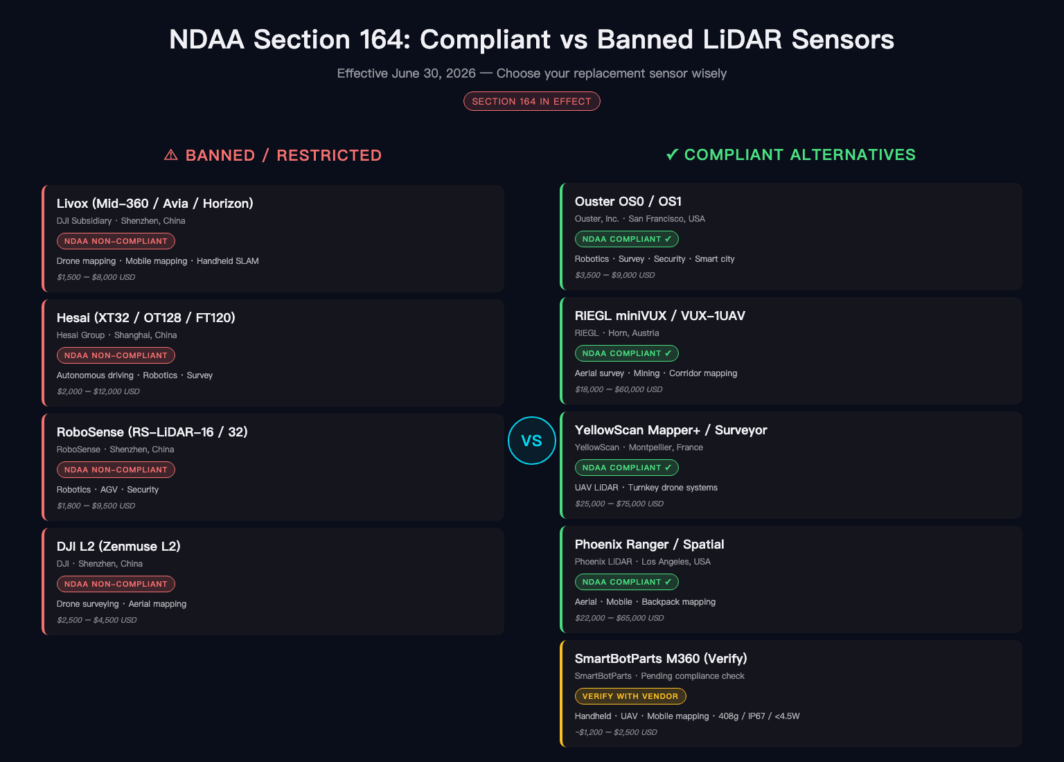
The compliant LiDAR market for survey applications is smaller than you might expect. Here's a practical comparison of options currently available to survey teams:
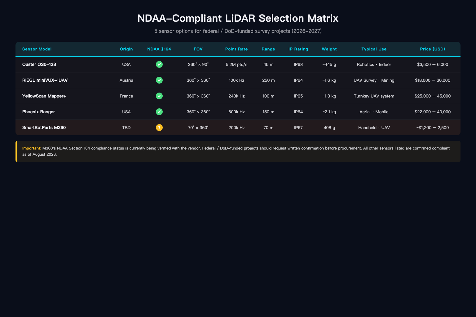
NDAA-Compliant Sensor Comparison Matrix
| Sensor System | Type | Range | Weight | NDAA Status | Blue UAS Listed | Price Range |
|---|---|---|---|---|---|---|
| Ouster OS1-128 | Spinning 360° | Up to 120m | 418g | Compliant | Yes | $12,000-18,000 |
| Ouster OS2-128 | Spinning 360° | Up to 200m | 560g | Compliant | Yes | $16,000-24,000 |
| RIEGL miniVUX-1UAV | Lightweight survey | Up to 160m | ~1.05kg | Compliant | Via integrators | $30,000-45,000 |
| RIEGL VZ-400i | Terrestrial | Up to 800m | ~9.8kg | Compliant | N/A (ground) | $80,000-120,000 |
| LightWare SF20/C | Compact/obstacle | Up to 100m | 55g | Compliant | Yes | $2,000-4,000 |
| Phoenix miniRANGER-3 | Integrated system | Configurable | Full system | Compliant | Yes (Blue) | $65,000-85,000 |
| YellowScan Venturer | Integrated UAV | Up to 150m | Full system | Compliant | Pending | $50,000-70,000 |
| Microdrones EasyOne NDAA | Integrated system | Configurable | Full system | Compliant | N/A | $45,000-65,000 |
Key Selection Criteria for Survey Teams
Point density at range. The Ouster OS series delivers 128-channel point clouds with strong density at moderate altitudes (60-80m AGL). RIEGL sensors offer longer range but at significantly higher cost and weight.
Weight constraints. If you're flying on a smaller multirotor (DJI Matrice 350 alternatives like the Freefly Alta X or Inspired Flight IF1200A), sensor weight directly affects flight time and coverage area. The Ouster OS1 at 418g or a LightWare unit at 55g leaves more payload budget for cameras and batteries.
Integrated vs. component. Integrated systems (Phoenix, YellowScan, Microdrones) bundle the sensor, GNSS/INS, and software into a tested package. They cost more but reduce integration risk and accelerate your transition timeline. Component purchases give you more flexibility but require in-house expertise to calibrate and integrate.
Software compatibility. Most compliant sensors work with common processing pipelines — LP360, Pix4Dsurvey, CloudCompare. But if your team relies on vendor-specific tools, verify compatibility before committing.
What About Cost and Budget Impact
For a mid-size survey firm running one or two drone LiDAR systems, the replacement cost is substantial. A typical Hesai-based system (sensor + drone + processing) cost $30,000-55,000 new. Moving to a compliant equivalent adds roughly 30-50% to that figure, depending on whether you go with an integrated system or build your own.
Several factors offset the sticker shock:
- Revenue preservation. Non-compliant equipment doesn't just block new DoD contracts — it can void existing ones if compliance clauses are triggered mid-project.
- Insurance and liability. Delivering survey data collected with non-compliant equipment on a federal project could create liability exposure for your firm.
- Future-proofing. The regulatory trend is expanding, not contracting. A 2026 bill introduced by Senators Blunt Rochester and Budd proposes extending LiDAR restrictions from DoD to the Department of Transportation. If passed, the affected project pool grows dramatically.
Step 4: Manage the Transition Period
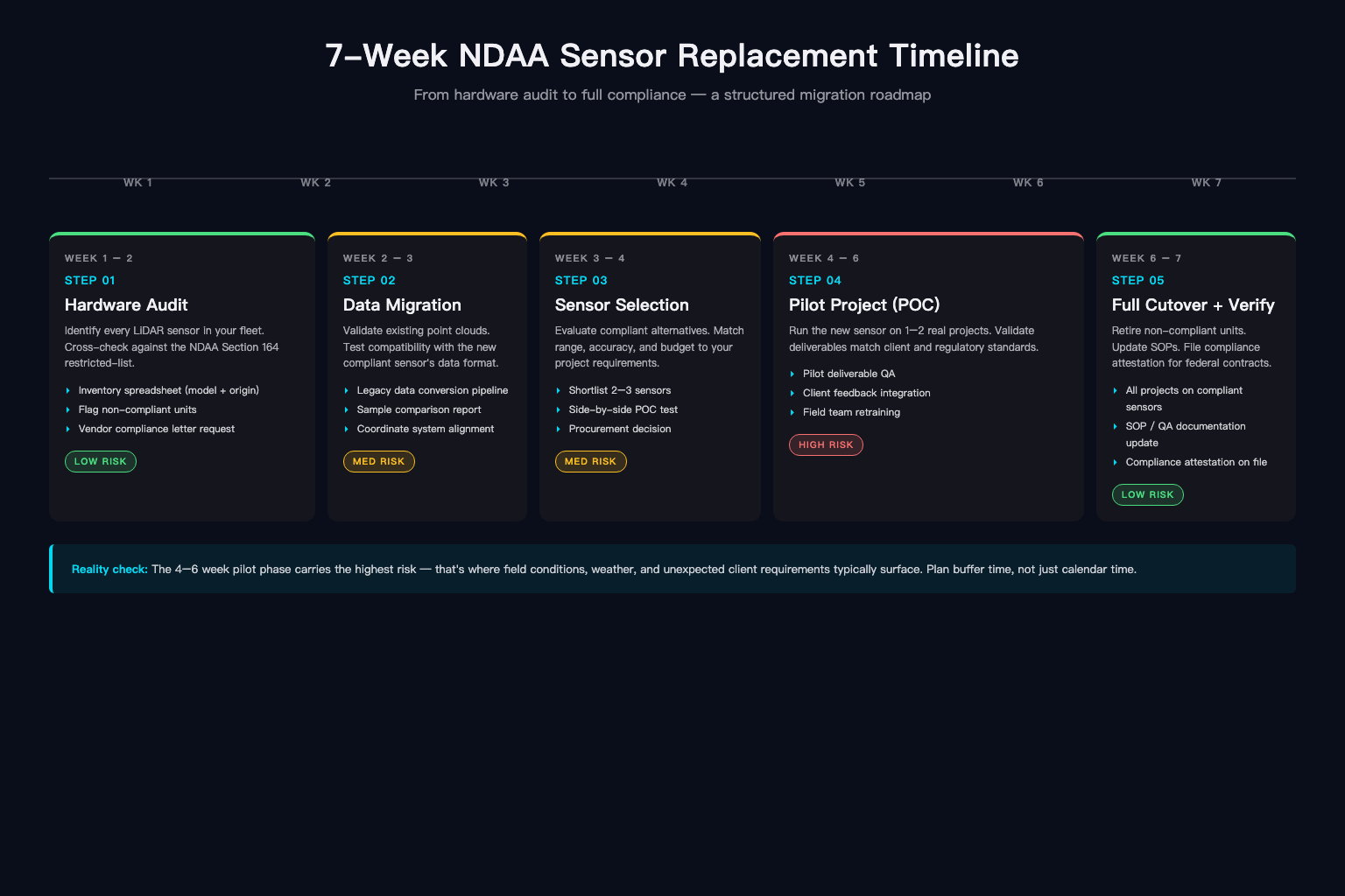
This is where most replacement plans fall apart. The practical challenge isn't picking a sensor — it's keeping your projects running while you switch.
Recommended Transition Timeline
Weeks 1-2: Procurement and delivery. Lead times on compliant sensors vary. Ouster products typically ship within 4-6 weeks. RIEGL systems can take 8-12 weeks. Integrated systems (Phoenix, YellowScan) run 6-10 weeks depending on configuration. Order early.
Weeks 3-4: Integration and training. If you're switching sensor types (Hesai spinning to Ouster spinning, or Hesai to RIEGL), expect calibration and workflow adjustment time. Your pilots and processing technicians need hands-on training with the new hardware and software.
Weeks 5-6: Parallel operations. Run both old and new sensors on 2-3 representative projects. Compare point cloud quality, density, accuracy against control points, and processing time. Document the differences.
Week 7+: Full cutover. Decommission the non-compliant hardware for federal work. Keep it available for purely private/commercial projects if that's an option, but maintain clear separation in your equipment tracking.
Project-Level Risk Assessment
For each active or upcoming project, evaluate three questions:
- Does the contract include an NDAA compliance clause? Review the fine print. Many teams discover that compliance requirements were baked into contracts they signed years ago, well before Section 164 existed.
- What's the deadline pressure? Projects with immediate field collection needs can't wait for a 6-week transition. You may need to subcontract the compliant portion or, in urgent cases, pursue the waiver process (Secretary of Defense can grant waivers, but certification to Congress is required and timelines are unpredictable).
- Can the project scope be adjusted? In some cases, switching from drone LiDAR to terrestrial scanning (RIEGL VZ series on a tripod) or photogrammetry with a compliant camera system can bridge the gap while your new drone LiDAR system is being set up.
Step 5: Verify Compliance — Don't Take the Manufacturer's Word for It
There is no single government-issued NDAA certification for LiDAR sensors. Manufacturers make compliance claims based on their own supply chain analysis. The only independent verification framework with real credibility right now is the DoD's Blue UAS Framework (also called the Blue List), administered by the Defense Innovation Unit.
Sensors and integrated systems on the Blue List have undergone cybersecurity and supply chain evaluation by DIU. It's not perfect, but it's the closest thing to an official stamp of approval.
Verification checklist:
- Check the Blue UAS Framework listing for the sensor and/or integrated system
- Request supply chain documentation from the manufacturer (component origin, software sourcing)
- Review the FAR Council's implementing regulations for Section 164 (published June 2026)
- Consult your contracting officer if you're unsure how compliance requirements apply to a specific project
- Document your compliance rationale in your project files — if audited, you'll need to show you performed due diligence
Regulatory Outlook: It's Probably Going to Get Stricter
Section 164 applies to DoD today. But the policy direction suggests broader application is coming:
- SAFE LiDAR Act (introduced December 2025): Would phase out LiDAR tied to foreign adversaries across transportation, infrastructure, and civilian markets. Not yet law, but signals congressional intent.
- DOT extension bill (introduced March 2026, led by Senators Blunt Rochester, Budd, Baldwin, and Cotton): Would extend Section 164 restrictions from DoD to the Department of Transportation, affecting FHWA, FAA, and FTA projects. If passed, nearly all federally funded survey work would require compliant equipment.
- FDD policy analysis (September 2025): Identified LiDAR as a critical technology where Chinese manufacturers (Hesai, RoboSense, Leishen, Livox) hold significant market share and called for urgent action.
For survey teams, the business case for transitioning now — even if your current contracts don't explicitly require it — is about avoiding a scramble when the next regulatory expansion hits.
Bottom Line
The NDAA LiDAR ban isn't a future problem. It's a now problem. Section 164 took effect June 30, 2026. If your team is running non-compliant sensors on federal work, the clock is ticking on your compliance window.
The replacement process is manageable, but it requires deliberate planning: audit your stack, pick a compliant sensor that fits your workflow and budget, build a realistic transition timeline, and document your compliance verification. Teams that treat this as a hardware swap will struggle. Teams that treat it as a workflow transition — data, software, training, contracts — will get through it with minimal project disruption.
Start now. The alternative is explaining to a contracting officer why you delivered survey data collected with banned equipment.
Regulatory information is based on publicly available legislative text and policy analysis as of August 2026. This guide is informational and does not constitute legal advice. Consult your contracting officer or legal counsel for project-specific compliance questions.